Būvniecība
A-GEO ir apņēmies būt jūsu stratēģiskais partneris būvniecībā.
Neatkarīgi no tā, vai esat iesaistīts infrastruktūras attīstībā, inženierbūvniecībā vai liela mēroga būvniecības projektos, mūsu risinājumi ir izstrādāti tā, lai atbilstu unikālajām būvniecības nozares prasībām. A-GEO nodrošinās jūs ar nepieciešamajām iekārtām un zināšanām, lai jūs varētu pārliecinoši un veiksmīgi pārvarēt problēmas, kas var rasties būvniecības jomā.
Šajā nozarē izmantotie instrumenti:
Matrice 30
The new DJI Matrice 30 is DJI Enterprise’s flagship drone that can be carried around in a backpack. Multiple high-performance sensors are integrated into a single camera payload, and the entire system is operated by an innovative redesigned remote control. It also runs on improved Pilot 2 software, which dramatically improves the flight experience.
Alpha Dozer
Alpha-GEO bulldozer leveling guidance system.
S990+
The Stonex S990+
is a high-performance GNSS receiver designed for
surveying applications. Equipped with 1408 channels, the S990+ can
provide real-time navigation solutions with high accuracy, supporting all
major GNSS constellations including GPS, GLONASS, BEIDOU,
GALILEO, and QZSS.
L300
L300 is a compact new generation of smart GNSS receiver designed for surveying project using the latest GNSS technology.
Zoom75
The GeoMax Zoom75 Series Robotic Total Station is packed with modern features to meet your surveying needs while remaining surprisingly affordable. This survey device is a smart choice for either construction professionals or surveying novices.
STX-DIG
Stonex machine control solutions can be installed in most earthmoving machines quickly and easily.
The simple design of the solution allows you to be up and running in no time. Thanks to the Android software developed by Stonex, all the components can easily communicate with each other. As an option there is the possibility of having a bluetooth connection between the various components of the system.
Zenith60
Become more productive and efficient with the Zenith60’s calibration-free tilt capability, making every
survey faster and more convenient. The antenna is resistant to magnetic interferences, so you can
enjoy the comfort of knowing you can trust your data.
Matrice 350 RTK
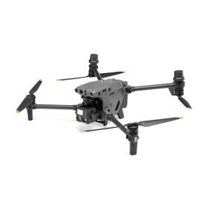
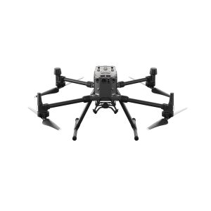
Elevate your professional operations with the DJI Matrice 350 RTK, a powerful and versatile drone designed for complex tasks. With unparalleled flight time, advanced sensor integration, and precise RTK positioning, it is the ideal aerial solution for inspections, mapping, and many other applications.