
F6
Highlights:
STONEX F6 is the market leader 3D handheld scanner for fast scanning of big objects and large areas from short to far ranges.
Based on a patent algorithm of innovative encoding F6 provides superb quality of data making it the ultimate device for scanning complex scenes within seconds.
Lixel K1 With 2 Batteries
Highlights:
Lixel K1 is a compact handheld scanning and modeling device newly
announced. With a lightweight body, it integrates 56 million-pixel
panoramic vision modules and a 360 ° LiDAR, capable of real-time
generation of centimeter-level colored 3D models. Tailored for
professionals, small to medium-sized businesses, and 3D enthusiasts,
it offers a convenient solution for 3D capture and modeling.

Lixel L2
Highlights:
Lixel L2 is an new generation handheld real-time 3D reconstruction laser scanner, achieving a 300-meter scanning range with ultra-high precision of +-1.2cm. It can instantly output color point cloud without external devices, generating data is thinner, purer and more uniform. It brings about a transformation in the efficiency and quality of 3D modeling and reality capture.
Pano Camera
Highlights:
Enhance your SLAM survey by adding important properties such as the 360° panoramic photos and visualize your point cloud with images for contextual image referencing.
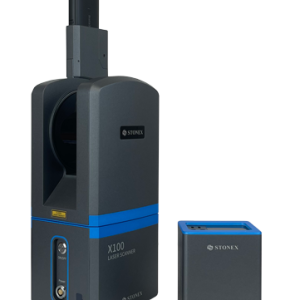
X100
Highlights:
X100 is a small and compact terrestrial laser scanner that is quick and easy to use. Its multi-line lidar technology and ability to achieve complete coverage of the surrounding area enable it to calculate 3D models for a wide range of applications and scenarios, both outdoors and indoors.
The scanner comes with its own X100app field app, making it easy to control the device. Thanks to the scan converter, the data is compatible with Cube-3d and Stonex Reconstructor, as well as third-party software.
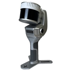
X120GO
Highlights:
X120GO system has a 360° rotating head, which can generate a 360°x270° point cloud coverage. Combined with the industry-level SLAM algorithm, it can obtain high-precision three-dimensional point cloud data of the surrounding environment without light and GPS. Equipped with three 5MP cameras to generate a 200°FOV horizontal and 100°FOV vertical, capable of synchronously obtaining texture information and producing colour point clouds and partial panoramic images.
X200GO
Highlights:
The X200GO is the latest generation system based on the SLAM technology, capable of covering any customer need.
The range of up to 300 metres and a rotating head that maximises the coverage of the laser beam make it versatile for any environment. Equipped with 2 cameras and RTK receiver for real-time point cloud colouring and orientation.
The two cameras provide navigable and measurable panoramic cameras superimposed on the 3D model. The system allows for the survey of static scans in X-Whizz mode, automatically aligned to the SLAM survey.
Backpack, shoulders hook, car mount and holder for DJI M350 can complete the system.
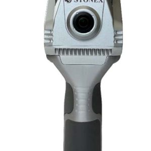
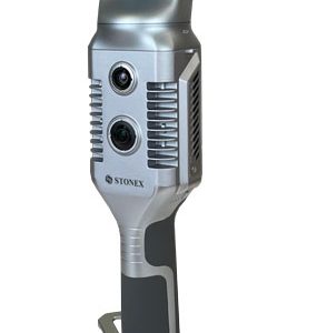
X40GO SLAM
Highlights:
X40G0 is a compact system providing high-precision point cloud data, based on SLAM technology.
The 70-meters range LiDAR orientation has been designed to maximize coverage and a 12-megapixel
camera provides texture information to the 3D model.
An affordable and simple solution, the idea for interior surveys and layout generation.
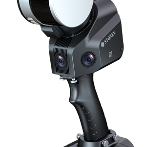
X70GO SLAM Laser Scanner
Highlights:
X70GO is a real-time 3D model reconstruction device which integrates inertial navigation module, high performance computer and storage system. It is equipped with a 360° rotating head, which, combined with the SLAM algorithm, generates high-precision point cloud data.
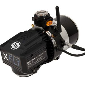
XFLY
Highlights:
XFLY series integrates high performance Inertial Navigation System with camera and LiDAR for point cloud generation. Different customer’s need can be met by the choice of Hesai LiDAR XFLY120, XFLY300 or other sensors.
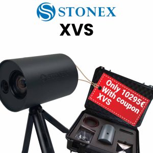
XVS
Highlights:
XVS system uses a technology based on the integration of high-resolution images, inertial systems and a complex algorithm: capturing a scenario with XVS, 3D model will be generated through photogrammetric techniques.
Walking and capturing the scene in motion, a real-time interface will guide you in the data collection, suggesting the speed of your movement and if necessary returning to an area to have enough image overlapping.
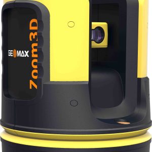
Zoom3D
Highlights:
Easy leveling, plumbing
points, and staking out:
Zoom3D’s unique and user
friendly onboard software
comes with a full set of
features that will speed up
your interior applications.