UAV LiDAR

Showing all 10 results

Show:

Explorer

Highlights:

The Explorer is the first compact, versatile and long range platform on the market. It is the culmination of several years of research and development done by YellowScan, while closely working alongside customers and partners from around the world.

Fly&Drive

Highlights:

The Fly & Drive is a versatile, land vehicle or UAV-mounted, mobile mapping system that combines high-resolution laser scanning and precise positioning to collect geo-referenced pointclouds.

Mapper

Highlights:

Start your LiDAR journey  with Yellowscan easy-to-use Mapper system. Its low weight, mid-range capability, top-end point density and advanced accuracy and precision, makes this LiDAR system the best value for money.

Mapper+

Highlights:

The YellowScan Mapper+ is the lightest three echoes and high-density LiDAR system.

Navigator

Highlights:

The YellowScan bathymetric LiDAR is an innovative solution for exploring underwater and ground topography with a single-button operation.

Its lightweight design allows for versatile platform selection without compromising water penetration.

Surveyor Ultra

Highlights:

With its 360° field of view, the YellowScan Surveyor Ultra answers vertical mapping and mobile mapping needs when combined with Fly&Drive. Expect unparalleled vegetation penetration thanks to this system’s 32 laser beams.

Voyager

Highlights:

The Voyager’s 100° laser scanner with its extremely fast data acquisition rate of up to 2400 kHz, makes this solution the best option for projects requiring the highest point density.

Vx15

Highlights:

Go from mapping inaccessible sites in the Balinese mountains to secluded areas in Chile.

Vx20

Highlights:

The Vx20 series is the ideal solution for high-flight projects with quick data processing needs. It is the most accurate system of the Vx series.

Zenmuse L2

Highlights:

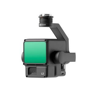
Zenmuse L2 integrates frame LiDAR, a self-developed high-accuracy IMU system, and a 4/3 CMOS RGB mapping camera, providing DJI flight platforms with more precise, efficient, and reliable geospatial data acquisition. When used with DJI Terra, it delivers a turnkey solution for 3D data collection and high-accuracy post-processing.

12,000.0013,000.00 ex. VAT
Scroll To Top
Close
Close

Shopping Cart

Close

Shopping cart is empty!

Continue Shopping

Sidebar